A Short Drive Through the Karakoram
In an ancient theatre of conflict, a traveller finds peace and good neighbourliness
By Ankur Shah
Last Updated: Jun 23, 2010, 06:32 IST10 min
You’re from Bombay? So what? You are like my brother!” Our guide’s voice rasps out through the lobby of the Eagles Nest Hotel in Pakistan’s Hunza valley. We had got through another Pakistani military checkpoint on our 1,250 km drive on the Karakoram Highway, from Islamabad to the Chinese border at Khunjerab, and I had just told him to keep my origins to himself.
The noise drops as the information travels. The attendants turn to look at us: “You’re from Bombay?”
We encounter this question often. But my concern over being identified as Indian in what I know as Pakistan-Occupied Kashmir was slowly replaced with the comforting knowledge that my inquisitors were just like gossiping neighbours back home.
The Karakoram is a formidable natural frontier. The range hosts seven of the 20 highest mountains on earth, including K2, at 8,611 metres, the second highest. It is the most heavily glaciated part of the earth outside the poles, and includes the 122-km-long Biafo-Hispar, the world’s longest glacial system.
Ringed by the Hindukush, Himalaya, Kunlun and Pamir ranges, the Karakoram is a gnarly, impenetrable knot. Some local kingdoms are still not fully assimilated into the country.
Politics hasn’t helped. In the 19th Century, Britain and Russia jockeyed here for influence in Central Asia, immortalised as ‘The Great Game’ in Kipling’s Kim. With ongoing conflict between India and Pakistan, and keen interest from China, Afghanistan, and Russia, the Karakoram continues to be the pivot of Asia.
On our journey to Gilgit, the last airstrip in the mountains, alpine forests and hilltops pass below our 15-seater airplane. We bank to dodge what looks like a whole mountain range. It turns out to be just one peak: Nanga Parbat, 8,126 metres, the world’s ninth highest mountain, so steep it suffers little snow. From the haze of the foothills, just south of the Indus, this massive rock forms a 30 km wall. It fills our window, and our minds.
Two days later, we climb our way through 40°C heat in the moraines of Raikot Gah, one of Nanga Parbat’s many glacial valleys. I turn a corner and confront the mountain again.
Nothing in our approach — from the rocky, barren Indus gorge — has prepared me for it. Avalanches thunder down the Raikot Face. I need to steady myself against the vertigo of finding the sky filled with ice and rock.
At Beyal Base Camp, on the second day, a sign points to Harmanbull lodge. Hermann Buhl was an Austrian, the first man to summit Nanga Parbat. He then stood the night out on a narrow ledge at 8,000 metres, holding on to the freezing rock for balance. In the wooden hut named for him, as we dip biscuits in steaming chai, it is hard to make room in our hearts for his travails. Reading on the veranda, in the afterglow of exertion, with a full stomach and the splendour of Nanga Parbat must surely count as one of life’s enduring pleasures.
Conversation with our driver during the jeep ride back to Gilgit turns to the chilling effect of the Taliban on tourism. I recall it has only been 20 years since this road was built. We are jolted back to thoughts of immediate survival, as our driver fails to overtake a heavy Chinese truck. We rage helplessly against the dust and carbon monoxide storms that billow behind it. Four hours later at Gilgit, caked with dust, numbed by the furnace-like heat of the rocky valleys, we resolve to take covered public transport to Hunza.
Overnight rains have cooled the burning slopes. We hum through scented orchards on the banks of the Indus.We have new friends: A dry-fruit seller from Islamabad, a real estate broker from Multan, women visiting relatives, homebound schoolchildren, a French-Canadian hippie who gets called out at every roadblock to provide further identification. My Hindi passes for the Urdu of a city slicker and I am spared as our neighbours take great pleasure in vouching for me.
Ali, the dry-fruit seller, delivers ceaseless commentary on passing historical and cultural sights: Here a bridge destroyed by floods in 1995 and rebuilt by the Chinese there a shrine to a local pir (saint) and a fort that fended off a British invasion in 1891. The bus stops at a roadside dhaba. We try a chapshuro — spiced minced lamb and cheese roasted in a fresh naan — which is delicious. Ali doesn’t let me pay. He invites us to dinner, writing down his address in our Lonely Planet.
The historian John Keay called Hunza an ‘incredible eyrie.’ Surrounded by mountains, frocked with deep green forests, the valley is rugged. The frontier is never far: In the forts, in the hazel eyes of a Hunza girl, in the growl of a dusty jeep navigating a hairpin bend. And it is lush. Bright orange apricots dangle tantalisingly, and lie squished, purple and matted, on the road below. Melt-water gurgles through irrigation canals and narrow gorges.
Jagged pearly peaks rings the valley: Rakaposhi, a soaring 7,800 metre peak, Diran, Sangemar Mar, Spantik, Distaghil, ending with Bubulimating, a finger of rock jutting above the Ultar glacier.
In the evening, as we sip fresh apricot juice on the balcony of our hotel, the sun drizzles the valley with softness and peak after peak lights up with orange fire. But there is more than a hint of intimacy with geopolitics. A monument to Queen Victoria sits on a ridge Baltit, with its now silent cannons overlooks the valley far below, on the twisting Karakoram Highway, signs read: ‘Long Live Pak China Friendship.’
We’ve already seen evidence of a Chinese victory in that old Great Game: Chinese-made bridges and trucks, and Chinese labourers chipping away at the spine of the Karakoram, hauling rubble to the cliff’s edge, mortaring retaining walls. They wear wide straw hats toothless grins brighten tanned, leathery skins. They wave as we pass.
The few Pakistanis we see seem to always be sitting around smoking. As Ali says: “The Chinese will make roads for us. We Pakistanis will teach them corruption!”

Image: Ankur Shah
In the late 19th Century, when Europeans first began to explore the north, the road was not even a passable trail. John Biddulph, the first European to return alive from Hunza, wrote: “On the occasion of my visit to Hunza in 1876, I suddenly found myself confronted with a more difficult and dangerous piece of ground than I had ever traversed in a tolerably large experience of Himalayan sport.”
A narrow trail, often without footholds, landslides down steep slopes, deadly rivers below, all made the road almost impervious to traffic.
But the British were paranoid about a Russian advance through the high passes of Central Asia, and subsequent invasion of Kashmir and then the plains of India. As the Great Game rose to a crescendo in the 1880s, British soldiers, politicians, and amateur explorers of all stripes attempted to build their careers on securing the Raj’s unknown flanks. The Karakoram proved impassable for infantry or artillery, but “the chance of a scrap” drove desperate and ambitious young men to Gilgit, the last British Agency in the north.
None was more ambitious than Colonel Algernon Durand, brother of the Foreign Secretary of British India (Henry Durand, after whom the Durand Line is named).
In the early 1890s, his Gilgit Agency launched two desperate, under-manned offensives, ostensibly to subjugate local kingdoms. Even as survey officers proclaimed, according to Keay, “We have no reason to fear a Russian advance through the passes,” Durand’s men attacked Chitral in the west. The subsequent mobilisation of the regular army to lift the siege on Durand’s men, and the extreme difficulty in crossing Malakand and Lowarai passes confirmed that the Karakoram would not bear the passage of armies.
As we near the border at Khunjerab Pass, we make way for one Chinese 18-wheeler container truck after another. The jawans at the final Pakistani outpost are delighted to see us. We share a swig of Chinese arak, and I grimace as I swallow, greatly amusing them. Beyond a windswept no-man’s land at the roof of the world, a new gateway to China is under construction: A ghastly replica of the entrance to the Forbidden City. The red flag with its five golden stars flutters above.
On the border, the mud track rises abruptly by two inches and becomes a four-lane tarmac road smooth enough to play carrom on. We are told it is like this all the way to Kashgar, in China’s Xinjiang Province, and will soon be the same to Islamabad, via the new 30-metre road we have seen being built by the Chinese. And onward via rail to Gwadar Port (built by the Chinese) on the Arabian Sea.
The glimpse of the rolling domes of the Pamirs and China’s staggering vision leaves me subdued.
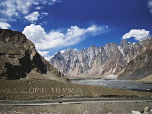
We spend the night by the Hunza River in Passu, a small village overshadowed by the mouth of a spiny glacier and Tupopdan, a dramatic cathedral of spire-shaped rocks. The cavernous, dimly lit dining space of the Soviet-inspired hotel is not welcoming. The food is oily and unappetising, but the Chinese beer is refreshing, and our host, Ahmed, is worldly and wise. My Indian identity opens a reservoir of goodwill. We talk about social isolation in big cities, where offering a ride to strangers is rare. Growing up in Passu, Ahmed and his friends rolled burning rubber tires down the slopes at night. The mountains create an unbearable urge, he explains, to escape the mental cage imposed by the high horizon and the narrow valley. Pyromania is suddenly understandable. Ahmed refuses payment and the night leaves a lump in my heart as we part with yet another stranger who opened his arms to us.
Two days later, the bus to Rawalpindi, 18 hours down the Karakoram Highway, pulls out of Gilgit without incident. We are in separate seats but our fellow passengers will not hear of it, and make room for us to sit together. At multiple breaks to replace flat tyres or stretch our legs, our companions share food, water, and their lives with us.
The man on my left is a branch manager of the National Bank of Agriculture from Siachen, going to Islamabad for training on a new loan product. He shows us pictures of his daughters on his cellphone, is curious about Lonely Planet’s assessment of his village and its touristic offerings. At Dassu, in lawless Indus Kohistan, he will not hear of us paying for our lunch. For once there are vegetables, and I savour the bhindi and lightly-fried green chillies.
At the Pir Wadhai terminal, Rawalpindi, a college friend has sent his car for us. The car, and the driver who rushes to take our bags, feel alien. We are like country bumpkins: Proud of our innocent adventure, warmed by our bonds with our neighbours, resentful of the big city lights that shine through the smog.
Half-way home, we realise we did not offer our banker friend a ride, or even wish him goodbye.

Map: Hemal Seth
IF YOU GO
How to Get There
To Gilgit: Fly from Islamabad on Pakistan International Airlines ($50 one way). Or take a NATCO bus from Rawalpindi (AC-ed, cheap). Or drive (12-24 hours, weather and road condition dependent, $250 one way).
Gilgit to Hunza and Khunjerab: public transport (cheap) or rent a jeep ($40/ day).
Where to Stay
Gilgit: Gilgit Serena, 4-star, luxurious but gaudy (Tel: +92 5811 455894, Doubles: $110/night). Lost Horizons, a guest house (doubles: $40/night, Tel: +92 5811 55017).
Hunza: Eagles Nest has spectacular views 30 minutes above Karimabad, free jeep transfers (doubles: $25/night with breakfast Tel: +92 58134 58274). Baltit Inn, a 4-star, (doubles: $72/night, Tel: +92 58134 57660).
Passu: only one small motel worth staying in as soon as you enter the town on the left.
Where to Eat
Hunza: Hidden Paradise, Karimabad, serves delicious traditional food. Café de Hunza has thick, fresh walnut cakes with crusted honey.
Passu: Glacier Breeze is the best in the valley delicious fresh apricot cake, Islamabad-trained chef/owner (Tel: +92 5822 50003).
Tips
ATMs only in Gilgit, but often not functional. Indian citizens must get location-specific visas from the Government of Pakistan.
First Published: Jun 23, 2010, 06:32
Subscribe Now(This story appears in the Nov 08, 2019 issue of Forbes India. To visit our Archives, Click here.)
